| diagram | 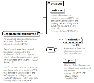 |
||||||||||||||
| namespace | http://www.fixm.aero/base/4.2 | ||||||||||||||
| children | fb:extension fb:pos | ||||||||||||||
| used by | |||||||||||||||
| attributes |
|
||||||||||||||
| annotation |
|
||||||||||||||
| source | <xs:complexType name="GeographicalPositionType"> <xs:annotation> <xs:documentation>An unnamed point designated only with a set of coordinates - latitude/longitude. [FIXM] Set of coordinates (latitude and longitude) referenced to the mathematical reference ellipsoid which define the position of a point on the surface of the Earth. [ICAO Annex 15] The "srsName" attribute names the coordinate reference system (CRS) that defines the semantics of the lat/long pair according to the ISO6709 standard. FIXM uses only "urn:ogc:def:crs:EPSG::4326".</xs:documentation> </xs:annotation> <xs:sequence> <xs:element name="extension" type="fb:GeographicalPositionExtensionType" nillable="true" minOccurs="0" maxOccurs="2000"> <xs:annotation> <xs:documentation>An extension hook for attaching extension (non-core) classes.</xs:documentation> </xs:annotation> </xs:element> <xs:element name="pos" type="fb:LatLongPosType" minOccurs="1" maxOccurs="1"> <xs:annotation> <xs:documentation>This list of doubles contains the latitude and longitude of the location in order of LATITUDE FIRST, THEN LONGITUDE.</xs:documentation> </xs:annotation> </xs:element> </xs:sequence> <xs:attribute name="srsName" type="xs:string" use="required" fixed="urn:ogc:def:crs:EPSG::4326"> <xs:annotation> <xs:documentation>Names the coordinate reference system (CRS) that defines the semantics of the lat/long pair according to the ISO6709 standard. FIXM uses only "urn:ogc:def:crs:EPSG::4326".</xs:documentation> </xs:annotation> </xs:attribute> </xs:complexType> |
attribute GeographicalPositionType/@srsName
| type | xs:string | ||||
| properties |
|
||||
| annotation |
|
||||
| source | <xs:attribute name="srsName" type="xs:string" use="required" fixed="urn:ogc:def:crs:EPSG::4326"> <xs:annotation> <xs:documentation>Names the coordinate reference system (CRS) that defines the semantics of the lat/long pair according to the ISO6709 standard. FIXM uses only "urn:ogc:def:crs:EPSG::4326".</xs:documentation> </xs:annotation> </xs:attribute> |
element GeographicalPositionType/extension
| diagram | 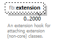 |
||||||||
| namespace | http://www.fixm.aero/base/4.2 | ||||||||
| type | fb:GeographicalPositionExtensionType | ||||||||
| properties |
|
||||||||
| annotation |
|
||||||||
| source | <xs:element name="extension" type="fb:GeographicalPositionExtensionType" nillable="true" minOccurs="0" maxOccurs="2000"> <xs:annotation> <xs:documentation>An extension hook for attaching extension (non-core) classes.</xs:documentation> </xs:annotation> </xs:element> |
element GeographicalPositionType/pos
| diagram | 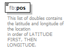 |
||||||
| namespace | http://www.fixm.aero/base/4.2 | ||||||
| type | fb:LatLongPosType | ||||||
| properties |
|
||||||
| facets |
|
||||||
| annotation |
|
||||||
| source | <xs:element name="pos" type="fb:LatLongPosType" minOccurs="1" maxOccurs="1"> <xs:annotation> <xs:documentation>This list of doubles contains the latitude and longitude of the location in order of LATITUDE FIRST, THEN LONGITUDE.</xs:documentation> </xs:annotation> </xs:element> |
XML Schema documentation generated by XMLSpy Schema Editor http://www.altova.com/xmlspy